Ice age, also called glacial age, any geologic period during which thick ice sheets cover vast areas of land. Such periods of large-scale glaciation may last several million years and drastically reshape surface features of entire continents. A number of ice ages have occurred throughout Earth history. The earliest known took place during Precambrian time dating back more than 570 million years. The most recent periods of widespread glaciation occurred during the Pleistocene Epoch (2.6 million to 11,700 years ago).
 A polar map shows five great ice caps or centres from which the ice moved outward during the ice age and to which it later retreated
 The blue areas are those that were covered by ice sheets in the past. The kansan and Nebraskan sheets overlapped almost the same area, and the Wisconsin and Illnosian sheets covered approximately the same territory. In the high altitudes of the West are the Cordilleran ice sheets. An area at the junction of Wisconsin, Minnesota, Iowa and Illinois was never entirely covered with ice.
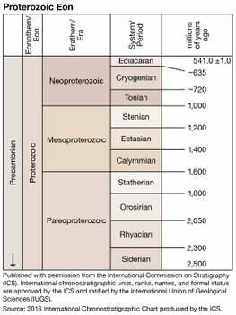 Source: 2016 International Chronostratigraphic Chart produced by the ICS
Copyright: Encyclopaedia Britannica, Inc.
A lesser, recent glacial stage called the Little Ice Age began in the 16th century and advanced and receded intermittently over three centuries in Europe and many other regions. Its maximum development was reached about 1750, at which time glaciers were more widespread on Earth than at any time since the last major ice ended about 11,700 years ago.
Copyright: Encyclopaedia Britannica, Inc.
Scientists have recorded five significant ice ages throughout the Earth's history: the Huronian (2.4-2.1 billion years ago), Cryogenian (720-635 million years ago), Andean-Saharan (460-430 million years ago), Karoo (360-260 million years ago) and Quaternary (2.6 million years ago- present).
Evidence For The Ice Ages:
A great deal of knowledge about the ice ages has been gained from the study of mountain glaciers. When a glacier moves downward out of its mountain source, it carves out a distinctive shape on the surrounding land. The deposits left by continental glaciers formed during the ice ages are in many ways comparable to those formed by mountain glaciers.
The transport of materials from one part of Earth's surface to another part is also evidence for continental glaciation. Rocks and fossils normally found only in the region may be picked up and moved by ice sheets and deposited elsewhere. The deposits and landforms left by the moving glacier provide evidence of ice sheet movement. In many cases, the moving ice leaves scratches (known as glacial grooves or striations) on the rock over which it moves, providing further evidence for changes that look place during an ice age.
Causes Of The Ice Ages:
Scientists have been investigating the causes of ice ages for more than a century. The answer to that question appears to have at least two main parts, astronomical factors and terrestrial factors. By astronomical factors, scientists mean that the way Earth is oriented in space can determine the amount of heat it receives and, hence its annual average temperature.
One of the most obvious astronomical factors about which scientists have long been curious is the appearance o sunspots. Sunspots are eruptions that occur on the Sun's surface during which unusually large amounts of solar energy are released. The number of sunspots that occur each year changes according to a fairly regular pattern, reaching a maximum about every 11 years or so. The increasing and decreasing amounts of energy sent out during sunspot maxima and minima, some scientists have suggested, may contribute in some way to the increase and decrease of ice fileds on Earth's surface.
1. Huronian Glaciation:
The Huronian Glaciation (or Makganyene Glaciation) was a glaciation that extended from 2.4 billion years to (Gya) to 2.1 billion years ago (Gya), during the Siderian and Rhyacian periods of the Paleoproterozoic era. The Huronian Glaciation followed the Great Oxidation Event (GOE), a time when increased atmospheric oxygen decreased atmospheric methane. The oxygen combined with the methane to form carbon dioxide and water, which do not retain heat as well as methane does. The glaciation led to a mass extinction on Earth.
In 1907, Arthur Philemon Coleman first inferred a "lower Huronian ice age" from analysis of a Geological formation near Lake Huron. This formation consists of two non-glacial sediment deposits found between three horizons of glacial deposits of the Huronian Supergroup deposited between 2.5 and 2.2 billion years ago.
2. Cryogenian
Cryogenian Period, second of three periods of the Neoproterozoic Era of geologic time, extending from approximately 720 million to approximately 635 million years ago. The Cryogenian Period followed the Tonian Period (which lasted from 1 billion to 720 million years ago) and was succeeded by the Ediacaran Period (approximately 635 million to approximately 541 million years ago). The beginning of the Cryogenian Period was defined arbitrarily: that is, it corresponded to the onset of the first glacial episode to follow the date of 750 million years ago.
For some 65 million years of the period's 85-million-year span, much if not all of Earth's surface was covered in ice. The Cryogenian's longest glaciation, the Sturtian, lasted for the period's first 50-60 million years. After a brief interglacial, a second cold interval, the Marinoan glaciation, dominated the planet for most of the period's final 15 million years. These two long glaciations are thought to have been caused by volcanic activity associated with the ongoing breakup of the Rodinia supercontinent, which started near the end of the Tonian Period. The emergence of the Laurentian basaltic provinence and other flood basalts produced by the massive outpouring of magma is thought to have resulted in increased weathering, a process that pulls carbon dioxide from the atmosphere. The global reach of the ice sheets and glaciers during the Sturtian and Marinoan glaciations is supported by the discovery of glacial deposits and other rocks that formed in the presence of ice near the location of Earth's Equator during the Cryogenian.
3. Andean-Saharan
The Andean-Saharan glaciation occured during the Paleozoic from 460 million years ago to 420 million years ago, during the late Ordovician and the Silurian period.
According to Eyles and Young, "A major glacial episode at c. 440 Ma, is recorded in Late Ordovician strata (predominantly Ashgillian) in West Africa (Tamadjert Formation of the Sahara), in Morocco (Tindouf Basin) and in west-central Saudi Arabia, all areas at polar latitudes at the time. From the Late Ordovician to the Early Silurian the centre of glaciation moved from northern Africa to southwestern South America".
During this period glaciation is known from Arabia, Sahara, West Africa, the south Amazon and the Andes. The maximum extent of glaciation developed in Africa and eastern Brazil.
4. Karoo
The Karoo Ice Age from 360-260 million years ago was the second major period of glaciation of the Phanerozoic Eon. It is named glacial tills found in the Karoo region of South Africa where evidence for this ice age was first clearly identified.
The tectonic assemble of the continents of Euramerica (later with the Uralian orogeny, into Laurasia) and Gondwana land into Pangea, in the Hercynian-Alleghany Orogeny, made a major continental landmass within the Antartic region, and the closure of the Rheic Ocean and lapetus Ocean saw disruption of warm water currents in the Panthalassa Ocean and Paleotethys Sea, which led to progressive cooling of summers, and the snowfields accumulating in winters, causing mountainous alpine glaciers to grow, and then spread out of highland areas, making continental glaciers which spread to cover much of Gondwana land.
At least two major periods of glaciation have been discovered-
* The first glacial period was associated with the Missississipian era (359.2 myr-318.1 myr); ice sheets expanded from a core in southern Africa and south America.
* The second glacial period was associated with the Pennsylvanian era (318.1 myr-299 myr); ice sheets expanded from a core in Australia and India.
5. Quaternary
The Quaternary glaciation, also known as the Pleistocene glaciation is an alternating series of glacial and interglacial periods during the Quartenary period that began 2.58 (million years ago), and is ongoing. Although Geologists describe the entire time period as an ice age, in popular culture the term "ice age" is usually associated with just the most recent glacial period during the Pleistocene. Since the planet Earth still has Ice sheets, geologists consider the Quaternary glaciation to be ongoing, with the Earth now experiencing an interglacial period.
Reference:
Note: The Post is reprinted from the materials provided by above references.
Comments
Post a Comment